Proposed GIS Project for West Boylston
What Is GIS?
GIS stands for Geographical Information System. A GIS is essentially a database used for creating maps. However, when used in conjunction with GIS software, it is really much more than "just" mapping software. Using GIS data, you can:
- plot streams, roads, watersheds, buildings (et.c.) in their exact locations
- compare the location of geographic features over time
- plot the effects of pollution
In addition to the host of environmental and scientific applications GIS has, it could be extremely useful for historical applications. Digitizing and georeferencing old maps could show interesting trends in:
- population migration over time
- how farming has developed in an area
- population shifts after the taking of land by eminent domain for roads, dams and reservoirs
Like a number of small towns across during the 20th century, West Boylston, Massachusetts was forced to rebuild itself when the Metropolitan District Commission decreed in the late 1800s that parts of the town (and neighboring Boylston, Sterling and Clinton) would have to be taken for a reservoir for Boston and the rest of eastern Massachusetts.
When you decide to start a GIS project, the first thing you need to do is to develop a question that manipulating GIS data will answer. To do a GIS project on the historical impact of the Wachusett Reservoir on West Boylston, we could ask the following question:
Where are the streets that existed in West Boylston, MA in 1892, relative to the Wachusett Reservoir that was built in the center of town in 1906?
Data Coverages
- 1855 -- roads and railroads, streams and watersheds in the Nashua River basin in West Boylston
- 1892 -- elevations in West Boylston
- 1992 -- roads and railroads, streams and watersheds, and elevations in the same area
The state of Massachusetts has an extensive set of modern data coverages at http://www.state.ma.us/mgis/massgis.htm. However, it has little in the way of antique maps and no historic data coverages. For a real project, the 1855 map would be digitized and completely georeferenced (while many of the roads in West Boylston have moved over the years, one set of train tracks are in the same location now that they were 150 years ago, so there is at least some basis for comparison). There is a good topological map from 1892 that would be digitized and georeferenced to show the "before the reservoir" elevations in the area.
Description of the Project Data
| Coverage Name | Feature Types | Contents |
|---|---|---|
| topo1892 | Polygons | Defines elevations, tics and study area from the 1892 topographic map |
| roads1855 | Arcs | Defines and codes all roads and train tracks from the 1855 town map. |
| streams1855 | Arcs | Identifies all streams from the 1855 town map |
| wtrshds1855 | Polygons | Identifies ponds from the 1855 town map |
| roads1992 | Arcs | Defines and codes all roads and train tracks from the 1992 Massachusetts GIS Web Site. |
| streams1992 | Arcs | Identifies all streams from the 1992 Massachusetts GIS Web Site. |
| wtrshds1992 | Polygons | Identifies all streams, reservoirs and ponds from the1992 Massachusetts GIS Web Site. |
As the three coverages were based on maps created at different times, they undoubtably have different scales and projections. Great care would need to be taken to be sure the data is correct and the same units are in force across the databases before merging any of the data.
Coverage Description and Data Layer Dictionaries
Item definitions for topo1892.aat
Elevation data
Calculated locations of TICs
roads1855 -- Item definitions for roads1855.aat
| Column | Item Name | Width | Output | Type | N. Dec |
|---|---|---|---|---|---|
| 1 | FNODE# | 4 | 5 | B | -- |
| 5 | FNODE# | 4 | 5 | B | -- |
| 9 | LPOLY# | 4 | 5 | B | -- |
| 13 | RPOLY# | 4 | 5 | B | -- |
| 17 | LENGTH | 4 | 12 | F | 3 |
| 21 | ROADS8# | 4 | 5 | B | -- |
| 25 | ROADS-ID8# | 4 | 5 | B | -- |
| 29 | RD-CODE8 | 1 | 1 | I | -- |
roads1855.lut
| Column | Item Name | Width | Output | Type | N. Dec |
|---|---|---|---|---|---|
| 1 | RD-CODE8 | 1 | 1 | I | -- |
| 2 | LABEL | 20 | 20 | C | -- |
| 21 | SYMBOL | 3 | 3 | I | -- |
The look-up table would differentiate the railroad tracks from roads. If the code is 1, it's a road, and if the code is 2, it's train tracks and would have a different symbol on the map.
streams1855 -- Item definitions for streams1855.aat
| Column | Item Name | Width | Output | Type | N. Dec |
|---|---|---|---|---|---|
| 1 | FNODE# | 4 | 5 | B | -- |
| 5 | FNODE# | 4 | 5 | B | -- |
| 9 | LPOLY# | 4 | 5 | B | -- |
| 13 | RPOLY# | 4 | 5 | B | -- |
| 17 | LENGTH | 4 | 12 | F | 3 |
| 21 | STREAMS# | 4 | 5 | B | -- |
| 25 | STREAMS-ID8# | 4 | 5 | B | -- |
wtrshds1855 -- Item definitions for wtrshds1855.aat
| Column | Item Name | Width | Output | Type | N. Dec |
|---|---|---|---|---|---|
| 1 | AREA | 4 | 12 | F | 3 |
| 5 | PERIMETER | 4 | 12 | F | 3 |
| 9 | WATER-ID8 | 4 | 5 | B | -- |
roads1992 (based on data from the Massachusetts GIS site)
Item definitions for roads1992.aat
| Column | Item Name | Width | Output | Type | N. Dec |
|---|---|---|---|---|---|
| 1 | FNODE# | 4 | 5 | B | -- |
| 5 | FNODE# | 4 | 5 | B | -- |
| 9 | LPOLY# | 4 | 5 | B | -- |
| 13 | RPOLY# | 4 | 5 | B | -- |
| 17 | LENGTH | 4 | 12 | F | 3 |
| 21 | ROADS# | 4 | 5 | B | -- |
| 25 | ROADS-ID# | 4 | 5 | B | -- |
| 29 | RD-CODE9 | 1 | 1 | I | -- |
| 30 | RDLABEL9 | 20 | 20 | C | -- |
roads1992.lut
| Column | Item Name | Width | Output | Type | N. Dec |
|---|---|---|---|---|---|
| 1 | RD-CODE9 | 1 | 1 | I | -- |
| 2 | LABEL | 20 | 20 | C | -- |
| 21 | SYMBOL | 3 | 3 | I | -- |
These are essentially the same tables as for roads1892 except some attribute names are slightly different so that when the datasets are merged, values are not overwritten.
streams1992 (data from the Massachusetts GIS site)
Item definitions for streams1992.aat
| Column | Item Name | Width | Output | Type | N. Dec |
|---|---|---|---|---|---|
| 1 | FNODE# | 4 | 5 | B | -- |
| 5 | FNODE# | 4 | 5 | B | -- |
| 9 | LPOLY# | 4 | 5 | B | -- |
| 13 | RPOLY# | 4 | 5 | B | -- |
| 17 | LENGTH | 4 | 12 | F | 3 |
| 21 | STREAMS# | 4 | 5 | B | -- |
| 25 | STREAMS-ID9# | 4 | 5 | B | -- |
wtrshds1992 (based on Map 2) -- Item definitions for wtrshds1855.aat
| Column | Item Name | Width | Output | Type | N. Dec |
|---|---|---|---|---|---|
| 1 | AREA | 4 | 12 | F | 3 |
| 5 | PERIMETER | 4 | 12 | F | 3 |
| 9 | WATER-ID9 | 4 | 5 | B | -- |
Coverages and Spatial Operations
| Selection Criteria | Data Layers | Suitable Areas | Spatial Model |
|---|---|---|---|
| Elevation info from the 1892 map | Elevation information | topo1892 | buffer1892 |
| Road and railroads in central West Boylston, 1855 | Layer showing roads and railroads in 1892 | roads1855 | buffer1855 |
| Streams in central West Boylston, 1855 | Layer showing streams in 1855 | streams1855 | |
| Ponds in central West Boylston, 1855 | Layer showing ponds in 1855 | wtrshds1855 | |
| Road and railroads in central West Boylston, 1992 | Layer showing town road and railroads in 1992 | roads1992 | buffer1992 |
| Streams in central West Boylston, 1992 | Layer showing streams in 1992 | streams1922 | |
| Reservoir and ponds in central West Boylston, 1992 | Layer showing pond and reservoir boundaries in 1992 | wtrshds1992 | |
| finalcov |
If GIS data generated from older maps were properly merged, the final map would look something like this:
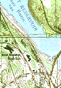 |
Current view of West Boylston with streets from
1855 roughly located in pink, courtesy of
Massachusetts Geographic Information System (MassGIS)
Partial 1855 street layout added by Laurie Trask Mann |